Tag Archives: ancient history

1,400 Year Old Monastery on Atlantic Island

Skellig Michael – Mysterious Monastery in the Atlantic

Saturday, March 26, 2011

Nine miles off the coast of County Kerry in the west of Ireland there are two small rocky islands peeking out of the Atlantic Ocean.  The larger of the two, Skellig Michael, is home to something quite extraordinary – a 1400 year old monastery which only a handful of people get to see each year.

As you approach the island there is little, seemingly, to notice.  Yet closer inspection reveals the tell tale criss-cross of manmade paths.   Who could possibly have wanted to live here – and when?

It is thought that the monastery of Skellig Michael was founded at some point in the seventh century and monastic life persisted there for over 600 years.  Why it was abandoned is lost in the sands of time but because of the sheer inaccessibility of the island what the monks left behind remained, through the centuries, remarkably intact.

The name of the island is taken from the Irish language and means Michael’s Rock.  It is some rock, too, rising to 230 meters at its summit.  Atop this the Gaelic Monastery has become well known globally but very few make the journey to visit the site – not many are allowed. This very fact has meant that because its remoteness necessarily discourages tourists that the monastery is, for its age, wonderfully preserved.

It is easy to imagine the early Irish Christian monks leading their extraordinarily spartan day to day existence here – to say that life would have been harsh for them is something of an understatement.  Their huts, in the shape of beehives and called clochans, indicate the bareness of life on the rock.  These monks would have shrugged off all of their earthly possessions before they came to live here. Although it is not by definition a hermitage it must surely have been a lonesome existence for the monks, despite the faith which initiated their decision to move there.

The monastery itself was terraced – a necessity because of the sheer sides of the rick.  Three flights of stairs (perhaps reflecting the Holy Trinity) lead up to Christ’s Valley which is the small depression between the peaks of Skellig Michael at 130 meters.  The visitor is not disappointed when greeted by the sight of six intact clochans.

Neither are they disappointed with the sight of the two oratories, graves and the monolithic cross which are to be discovered there.  There is more recent addition too – a church which was built as late as the thirteenth century.  The construction must have been a labor – the walls are almost two meters thick.

Although Skellig Michael was not intended as such there is a hermitage on the island, distinct from the monastery.   As if a rock in the Atlantic was not isolated enough this extreme form of retreat afforded those monks who wished to contemplate the divine in complete isolation the opportunity to do so.

Daily life and its demands also had to be taken in to account and there is a latrine on the island which is situated over an enormously yawning gap in the rock to ensure that waste matter was thoroughly disposed of.  There are also the remains of a garden which the monks would use to grow essential vegetables.

There is evidence that Skellig Michael suffered several Viking raids, though quite what the visitors from the north would have hoped to pillage is questionable.  However, these raids may have caused the monks to decamp to the mainland in the twelfth century even though the later chapel was built at around the same time. One can only attempt to imagine the dread that the isolated and virtually defenceless monks must have felt at the sight of an approaching Viking longship.

As a result of the deterioration of the monastery due to the tramp of tourists’ feet, the decision was taken to severely restrict the number of visitors to the island.  13 licenses are given to tour operators annually and each may only make a single trip to the rock.

It is thought that there were never more than a dozen or so monks on the island at any one time plus an abbot.  The mystery as to the abandonment of the rock is never likely to be satisfactorily solved but in many ways the monks did the rest of the world a favor.  It is unlikely that what we see now on the island would have remained intact if the island had continued to be populated.  Its very abandonment ensured its survival.

1 Comment

Filed under Humor and Observations

500-million-year-old sea creature found

500-million-year-old sea creature found

By Tia Ghose

Published February 28, 2013

LiveScience

  • arthropod-fossil-2

    Scientists have unearthed a stunningly preserved arthropod, called a fuxhianhuiid, in a flipped position that reveals its feeding limbs and nervous system. (Yie Jang (Yunnan University))

Scientists have unearthed extraordinarily preserved fossils of a 520-million-year-old sea creature, one of the earliest animal fossils ever found, according to a new study.

The fossilized animal, an arthropod called a fuxhianhuiid, has primitive limbs under its head, as well as the earliest example of a nervous system that extended past the head. The primitive creature may have used the limbs to push food into its mouth as it crept across the seafloor. The limbs may shed light on the evolutionary history of arthropods, which include crustaceans and insects.

‘This is as early as we can currently see into arthropod limb development.’

– Javier Ortega-Hernández, an earth scientist at the University of Cambridge 

“Since biologists rely heavily on organization of head appendages to classify arthropod groups, such as insects and spiders, our study provides a crucial reference point for reconstructing the evolutionary history and relationships of the most diverse and abundant animals on Earth,” said study co-author Javier Ortega-Hernández, an earth scientist at the University of Cambridge, in a statement. “This is as early as we can currently see into arthropod limb development.”

The findings were published Wednesday, Feb. 27, in the journal Nature.

Primordial animal

The fuxhianhuiid lived nearly 50 million years before animals first emerged from the sea onto land, during the early part of the Cambrian explosion, when simple multicellular organisms rapidly evolved into complex sea life. [See Images of the Wacky Cambrian Creatures ]

While paleontologists have unearthed previous examples of a fuxhianhuiid before, the fossils were all found in the head-down position, with their delicate internal organs obscured by a large carapace or shell.

However, when Ortega-Hernández and his colleagues began excavating in a fossil-rich region of southwest China around Kunming called Xiaoshiba, they unearthed several specimens of fuxhianhuiid where the bodies had been flipped before fossilization. All told, the team unearthed an amazingly preserved arthropod, as well as eight additional specimens.

These primeval creatures probably spent most of their days crawling across the seabed trawling for food and may have also been able to swim short distances. The sea creatures, some of the earliest arthropods or jointed animals, probably evolved from worms with legs.

The discovery sheds light on how some of the earliest ancestors of today’s animals may have evolved.

“These fossils are our best window to see the most primitive state of animals as we know them – including us,” Ortega-Hernández said in a statement. “Before that there is no clear indication in the fossil record of whether something was an animal or a plant – but we are still filling in the details, of which this is an important one.”

Read more: http://www.foxnews.com/science/2013/02/28/500-million-year-old-sea-creature/?intcmp=obinsite#ixzz2NjmkstbB

Leave a comment

Filed under Humor and Observations

Ancient Arctic Camel

Ancient Arctic camel a curious conundrum

Published March 05, 2013

Associated Press

  • Pliocene Candian Camel.jpg

    The High Arctic camel on Ellesmere Island during the Pliocene warm period, about 3.5 million years ago. The camels lived in a boreal-type forest that included larch trees; the depiction is based on records of plant fossils found at nearby fossil deposits. (Julius Csotonyi)

  • Pliocene Candian Camel 1.jpg

    The fossil bones of the High Arctic Camel laid out in Dr. Rybczynski’s lab at the Canadian Museum of Nature. The fossil evidence consists of about 30 bone fragments, which together form part of a limb bone of a Pliocene camel. (Martin Lipman, Canadian Museum of Nature)

  • Pliocene Candian Camel 2.jpg

    View of Camp 2 at the Fyles Leaf Bed Site on Ellesmere Island, near Strathcona Fiord. Across the valley lay exposed tilted Devonian-era beds, partially obscured by low-lying cloud. (Martin Lipman, Canadian Museum of Nature)

  • Pliocene Candian Camel 3.jpg

    A fragment of the camel fossil lying in situ on the Fyles Leaf Bed site. The fossil looks very similar to wood. The fossil evidence consists of about 30 bone fragments, which together form part of a limb bone of a Pliocene camel.Found on Ellesmere Island, this is the northernmost discovery of camels in the Arctic, about 1,200 km further north than the Yukon camel.The fossil record from this area shows the camel lived about 3.5 million years ago, when the region supported a boreal-type forest.Ellesmere Island..”Fyles Leaf Bed site” refers to an exposure located about 9 km Southwest of the Beaver Pond site near Strathcona Fiord. The section was visited previously by John Fyles (Geological Survey of Canada), and briefly in 1992 by Fyles and Richard Harington. In 1992 they prospected for about 2 hours. The first detailed stratigraphic work on the site was by Adam Csank (supervised by Jim Basinger) as part of his M.Sc. thesis (2006). At the time Adam measured 40 m of section, but in 2008 John Gosse determined that the Tertiary section was 90 m in thickness. (Martin Lipman, Canadian Museum of Nature)

OTTAWA –  Ancient, mummified camel bones dug from the tundra confirm that the animals now synonymous with the arid sands of Arabia actually developed in subfreezing forests in what is now Canada’s High Arctic, a scientist said Tuesday.

About 3.5 million years ago, Strathcona Fiord on Ellesmere Island’s west-central coast would have looked more like a northern forest than an Arctic landscape, said paleobotanist Natalia Rybczynski of the Canadian Museum of Nature in Ottawa.

“Larch-dominated, lots of wetlands, peat,” said Rybczynski, lead author of a study published Tuesday in the journal Nature Communications. Nearby fossil sites have yielded evidence of ancient bears, horses, deer, badgers and frogs. The average yearly temperature would have been about 32 Fahrenheit.

“If you were standing in it and watching the camel, it would have the feel of a boreal-type forest.”

The Arctic camel was 30 percent larger than modern camels, she said. Her best guess is it was one-humped.

Although native camels are now only found in Africa and Asia, scientists have long believed the species actually developed in North America and later died out. Camel remains have been previously found in the Yukon.

What makes Rybczynski’s find special is not only how far north it was found, but its state of preservation.

The 30 fragments found in the sand and pebbles of the tundra were mummified, not fossilized. So despite their age, the pieces preserved tiny fragments of collagen within them, a common type of protein found in bones.

Analyzing that protein not only proved the fragments were from camels, but from a type of camel that is much more closely related to the modern version than the Yukon camel. Out of the dozens of camel species that once roamed North America, the type Rybczynski found was one of the most likely to have crossed the Bering land bridge and colonized the deserts.

“This is the one that’s tied to the ancestry of modern camels,” she said.

Read more: http://www.foxnews.com/science/2013/03/05/ancient-arctic-camel-curious-conundrum/?intcmp=features#ixzz2NNHSu4Ih

2 Comments

Filed under Animals, Humor and Observations

Mummies Show Clogged Arteries 4,000 years ago.

Even 4,000 year-old mummies had clogged arteries, study reveals

Published March 11, 2013

Associated Press

  • MummyHeartDisease.JPG

    March 10, 2013: A a group of cardiologists lead by Saint Luke’s Mid America Heart Institute in Kansas City, USA, show the mummy Hatiay (New Kingdom, 18th Dynasty, 1550 to 1295 BCE) as it is returned to its display back in the Antiquities Museaum in Cairo after it underwent a CT scanning. (AP)

  • Egypt Mummies Heart Disease 1.jpg

    March 10, 2013: The sarcophagus of the mummy Hatiay (New Kingdom, 18th Dynasty, 1550 to 1295 BCE) is closed after the mummy underwent a CT scanning, in Cairo, Egypt. (AP Photo/Dr. Michael Miyamoto)

  • Egypt Mummies Heart Disease 2.jpg

    March 10, 2013: Egyptologists prepare the mummy Hatiay (New Kingdom, 18th Dynasty, 1550 to 1295 BCE) for CT scanning in Cairo, Egypt, which later demonstrated evidence of extensive vascular disease. (AP Photo/Dr. Michael Miyamoto)

  • Egypt Mummies Heart Disease.jpg

    March 10, 2013: The mummy Hatiay (New Kingdom, 18th Dynasty, 1550 to 1295 BCE) gets a CT scan in Cairo, Egypt, where it was found to have evidence of extensive vascular disease. (AP Photo/Dr. Michael Miyamoto)

Even without modern-day temptations like fast food or cigarettes, people had clogged arteries some 4,000 years ago, according to the biggest-ever hunt for the condition in mummies.

Researchers say that suggests heart disease may be more a natural part of human aging rather than being directly tied to contemporary risk factors like smoking, eating fatty foods and not exercising.

‘Heart disease has been stalking mankind for over 4,000 years.’

– Dr. Randall Thompson, a cardiologist at Saint Luke’s Mid America Heart Institute in Kansas City 

CT scans of 137 mummies showed evidence of atherosclerosis, or hardened arteries, in one third of those examined, including those from ancient people believed to have healthy lifestyles. Atherosclerosis causes heart attacks and strokes. More than half of the mummies were from Egypt while the rest were from Peru, southwest America and the Aleutian islands in Alaska. The mummies were from about 3800 B.C. to 1900 A.D.

“Heart disease has been stalking mankind for over 4,000 years all over the globe,” said Dr. Randall Thompson, a cardiologist at Saint Luke’s Mid America Heart Institute in Kansas City and the paper’s lead author.

The mummies with clogged arteries were older at the time of their death, around 43 versus 32 for those without the condition. In most cases, scientists couldn’t say whether the heart disease killed them.

The study results were announced Sunday at a meeting of the American College of Cardiology in San Francisco and simultaneously published online in the journal Lancet.

Thompson said he was surprised to see hardened arteries even in people like the ancient Aleutians who were presumed to have a healthy lifestyle as hunter-gatherers.

“I think it’s fair to say people should feel less guilty about getting heart disease in modern times,” he said. “We may have oversold the idea that a healthy lifestyle can completely eliminate your risk.”

Thompson said there could be unknown factors that contributed to the mummies’ narrowed arteries. He said the Ancestral Puebloans who lived in underground caves in modern-day Colorado and Utah, used fire for heat and cooking, producing a lot of smoke.

“They were breathing in a lot of smoke and that could have had the same effect as cigarettes,” he said.

Previous studies have found evidence of heart disease in Egyptian mummies, but the Lancet paper is the largest survey so far and the first to include mummies elsewhere in the world.

Dr. Frank Ruehli of the University of Zurich, who runs the Swiss Mummy Project, said it was clear atherosclerosis was notably present in antiquity and agreed there might be a genetic predisposition to the disease.

“Humans seem to have a particular vulnerability (to heart disease) and it will be interesting to see what genes are involved,” he said. Ruehli was not connected to the study. “This is a piece in the puzzle that may tell us something important about the evolution of disease.”

Other experts warned against reading too much into the mummy data.

Dr. Mike Knapton, associate medical director at the British Heart Foundation, said calcified arteries could also be caused by other ailments including endocrine disorders and that it was impossible to tell from the CT scans if the types of calcium deposits in the mummies were the kind that would have sparked a heart attack or stroke.

“It’s a fascinating study but I’m not sure we can say atherosclerosis is an inevitable part of aging,” he said, citing the numerous studies that have showed strong links between lifestyle factors and heart disease.

Researcher Thompson advised people to live as healthy a lifestyle as possible, noting that the risk of heart disease could be reduced with good eating habits, not smoking and exercising. “We don’t have to end up like the mummies,” he said.

Read more: http://www.foxnews.com/science/2013/03/11/study-reveals-even-4000-year-old-mummies-had-clogged-arteries/?intcmp=related#ixzz2NNFOasby

1 Comment

Filed under Humor and Observations

Legendary Viking “Sunstone” real?

Is legendary Viking ‘sunstone’ real?

By Megan Gannon

Published March 10, 2013

LiveScience

  • viking-crystal

    Researchers say this crystal found at the Alderney shipwreck near the Channel Islands could prove fabled Viking sunstones really did exist. (© Alderney Museum)

Ancient lore has suggested that the Vikings used special crystals to find their way under less-than-sunny skies. Though none of these so-called “sunstones” have ever been found at Viking archaeological sites, a crystal uncovered in a British shipwreck could help prove they did indeed exist.

The crystal was found amongst the wreckage of the Alderney, an Elizabethan warship that sank near the Channel Islands in 1592. The stone was discovered less than 3 feet from a pair of navigation dividers, suggesting it may have been kept with the ship’s other navigational tools, according to the research team headed by scientists at the University of Rennes in France.

If you were to look at someone’s face through a clear chunk of Icelandic spar, you would see two faces. 

A chemical analysis confirmed that the stone was Icelandic Spar, or calcite crystal, believed to be the Vikings’ mineral of choice for their fabled sunstones, mentioned in the 13th-century Viking saga of Saint Olaf.

Today, the Alderney crystal would be useless for navigation, because it has been abraded by sand and clouded by magnesium salts. But in better days, such a stone would have bent light in a helpful way for seafarers.

Because of the rhombohedral shape of calcite crystals, “they refract or polarize light in such a way to create a double image,” Mike Harrison, coordinator of the Alderney Maritime Trust, told LiveScience. This means that if you were to look at someone’s face through a clear chunk of Icelandic spar, you would see two faces. But if the crystal is held in just the right position, the double image becomes a single image and you know the crystal is pointing east-west, Harrison said.

These refractive powers remain even in low light when it’s foggy or cloudy or when twilight has come. In a previous study, the researchers proved they could use Icelandic spar to orient themselves within a few degrees of the sun, even after the sun had dipped below the horizon.

European seafarers had not fully figured out magnetic compasses for navigation until the end of 16th century. The researchers say the crystal might have been used on board the Elizabethan ship to help correct for errors with a magnetic compass.

“In particular, at twilight when the sun is no longer observable being below the horizon, and the stars still not observable, this optical device could provide the mariners with an absolute reference in such situation,” the researchers wrote online this week in the journal Proceedings of the Royal Society A.

No such crystals have been found yet at Viking sites. The team notes that archaeologists are unlikely to find complete crystals as part of a group of grave goods, since the Vikings often cremated their dead.

But recent excavations turned up the first calcite fragment at a Viking settlement, “proving some people in the Viking Age were employing Iceland spar crystals,” the researchers wrote.

Read more: http://www.foxnews.com/science/2013/03/10/first-evidence-viking-sunstone-found/?intcmp=features#ixzz2NIgtRywA

Leave a comment

Filed under Humor and Observations

Ancient Shoes Found In Egypt

Lost and found: Ancient shoes turn up in Egypt temple

By Owen Jarus

Published February 28, 2013

LiveScience

  • 4-Egypt-shoe-discovery

    The unwrapped shoe bundle showing the two pairs of children’s shoes and the adult isolate. (© 2005 Franco M. Giani – Milano – Italy)

More than 2,000 years ago, at a time when Egypt was ruled by a dynasty of kings of Greek descent, someone, perhaps a group of people, hid away some of the most valuable possessions they had — their shoes.

Seven shoes were deposited in a jar in an Egyptian temple in Luxor, three pairs and a single one. Two pairs were originally worn by children and were only about 7 inches long. Using palm fiber string, the child shoes were tied together within the single shoe (it was larger and meant for an adult) and put in the jar. Another pair of shoes, more than 9 inches long that had been worn by a limping adult, was also inserted in the jar.

The shoe-filled jar, along with two other jars, had been “deliberately placed in a small space between two mudbrick walls,” writes archaeologist Angelo Sesana in a report published in the journal Memnonia.

Whoever deposited the shoes never returned to collect them, and they were forgotten, until now. [See Photos of the Ancient Egyptian Shoes]

‘The shoes were in pristine condition and still supple upon discovery.’

– André Veldmeijer, an expert in ancient Egyptian footwear 

In 2004, an Italian archaeological expedition team, led by Sesana, rediscovered the shoes. The archaeologists gave André Veldmeijer, an expert in ancient Egyptian footwear, access to photographs that show the finds.

“The find is extraordinary as the shoes were in pristine condition and still supple upon discovery,” writes Veldmeijer in the most recent edition of the Journal of the American Research Center in Egypt. Unfortunately after being unearthed the shoes became brittle and “extremely fragile,” he added.

Pricey shoes
Veldmeijer’s analysis suggests the shoes may have been foreign-made and were “relatively expensive.” Sandals were the more common footwear in Egypt and that the style and quality of these seven shoes was such that “everybody would look at you,” and “it would give you much more status because you had these expensive pair of shoes,” said Veldmeijer, assistant director for Egyptology of the Netherlands-Flemish Institute in Cairo.

The date of the shoes is based on the jar they were found in and the other two jars, as well as the stratigraphy, or layering of sediments, of the area. It may be possible in the future to carbon date the shoes to confirm their age.

Why they were left in the temple in antiquity and not retrieved is a mystery. “There’s no reason to store them without having the intention of getting them back at some point,” Veldmeijer said in an interview with LiveScience, adding that there could have been some kind of unrest that forced the owners of the shoes to deposit them and flee hastily. The temple itself predates the shoes by more than 1,000 years and was originally built for pharaoh Amenhotep II (1424-1398 B.C.).

Design discoveries
Veldmeijer made a number of shoe design discoveries. He found that the people who wore the seven shoes would have tied them using what researchers call “tailed toggles.” Leather strips at the top of the shoes would form knots that would be passed through openings to close the shoes. After they were closed a long strip of leather would have hung down, decoratively, at either side. The shoes are made out of leather, which is likely bovine.

Most surprising was that the isolated shoe had what shoemakers call a “rand,” a device that until now was thought to have been first used in medieval Europe. A rand is a folded leather strip that would go between the sole of the shoe and the upper part, reinforcing the stitching as the “the upper is very prone to tear apart at the stitch holes,” he explained. The device would’ve been useful in muddy weather when shoes are under pressure, as it makes the seam much more resistant to water.

In the dry (and generally not muddy) climate of ancient Egypt, he said that it’s a surprising innovation and seems to indicate the seven shoes were constructed somewhere abroad.

Health discoveries
The shoes also provided insight into the health of the people wearing them. In the case of the isolated shoe, he found a “semi-circular protruding area” that could be a sign of a condition called Hallux Valgus, more popularly known as a bunion. [The 9 Most Bizarre Medical Conditions]

“In this condition, the big toe starts to deviate inward towards the other toes,” Veldmeijer writes in the journal article. “Although hereditary, it can also develop as a result of close fitting shoes, although other scholars dispute this ….”

Another curious find came from the pair of adult shoes. He found that the left shoe had more patches and evidence of repair than the shoe on the right. “The shoe was exposed to unequal pressure,” he said, showing that the person who wore it “walked with a limp, otherwise the wear would have been far more equal.”

Still, despite their medical problems, and the wear and tear on the shoes, the people who wore them were careful to keep up with repairs, Veldmeijer said. They did not throw them away like modern-day Westerners tend to do with old running shoes.

“These shoes were highly prized commodities.”

Veldmeijer hopes to have the opportunity to examine the shoes, now under the care of the Ministry of State for Antiquities, firsthand.

Read more: http://www.foxnews.com/science/2013/02/28/lost-and-found-ancient-shoes-turn-up-in-egypt-temple/?intcmp=obinsite#ixzz2NIf3IGOv

1 Comment

Filed under Humor and Observations

Sunken Cities Of The Ancient World

Sunken Cities Of The Ancient World

AUGUST 2, 2011

Though finding Atlantis may still be a pipe dream, these cities, long submerged in the depths of their surrounding oceans, provide enough mystery and wonder to whet your imaginations.

Cleopatra’s Kingdom, Alexandria, Egypt

we4Md Sunken Cities Of The Ancient World

Lost for 1,600 years, the royal quarters of Cleopatra were discovered off the shores of Alexandria. A team of marine archaeologists, led by Frenchman, Franck Goddio, began excavating the ancient city in 1998. Historians believe the site was submerged by earthquakes and tidal waves, yet, astonishingly, several artifacts remained largely intact. Amongst the discoveries were the foundations of the palace, shipwrecks, red granite columns, and statues of the goddess Isis and a sphinx. The Egyptian Government plans to create an underwater museum and hold tours of the site.

1uj3n Sunken Cities Of The Ancient World

dUZYr Sunken Cities Of The Ancient World

HAosg Sunken Cities Of The Ancient World

FZjVQ Sunken Cities Of The Ancient World

Bay of Cambay, India

XmnGi Sunken Cities Of The Ancient World

The Bay of Cambay was discovered by marine scientists in early 2002. The city is located 120 feet underwater in the Gulf of Cambay off the western coast of India. The city is five miles long and two miles wide, carbon dating estimates the site to be a whopping 9,500 years old, and, more amazingly, architectural and human remains are still intact. The discovery astounded scientists because it predates all other finds in the area by 5,000 years, suggesting a much longer history of the civilization than was first assumed. Marine scientists used sonar images and sum-bottom profiling to locate the lost ruins and it is believed the area was submerged when the ice caps melted in the last Ice Age. The Indian nationals have dubbed the find ‘Dwarka’ (The Golden City) in honor of ancient submerged city said to belong to Hindu god, Krishna.

Dpyxp Sunken Cities Of The Ancient World

Port Royal, Jamaica

NAs6L Sunken Cities Of The Ancient World

Once referred to as the ‘Wickedest City on Earth’ (because of its rampant piracy, prostitution and rum consumption), part of Port Royal sank after an earthquake in 1692. The ruins scattered in the Kingston Harbor, and currently, the remains of the city encompasses 13 acres at depths of up to 40 feet. Archaeological investigations of the site began in 1981, led by the Nautical Archaeology Program of Texas A&M University. The investigations unearthed historical documents, organic artefacts and vast amount of architectural debris.

YnukN Sunken Cities Of The Ancient World

Yonaguni-Jima, Japan

YXMyc Sunken Cities Of The Ancient World

Some 68 miles past the east coast of Taiwan, off the coast of Yonaguni Islands, a sunken ruin was discovered by a sport diver, in 1995. The ruins are estimated to be around 8,000 years old, however, it is still unclear which missing city they made up. The most spectacular discovery amongst the submerged ruins is a large pyramid structure, finely designed archways resembling the Inca civilization, staircases and hallways, and carved stones.

Nvw7n Sunken Cities Of The Ancient World

y8LS3 Sunken Cities Of The Ancient World

v0YLc Sunken Cities Of The Ancient World

Baiae and Portus Julius, Italy

gJ7nJ Sunken Cities Of The Ancient World

Baiae was an ancient Roman town overlooking the Bay of Naples, where rich Romans and emperors whiled away their time in their villas. It was also connected to the Roman Empire’s biggest naval base, Portus Julius. However, the town and port were built on a tract of volcanic land, the activity of which is said to have caused the structure to collapse into the ocean.

AXmaR Sunken Cities Of The Ancient World

w6Mvn Sunken Cities Of The Ancient World

Pavlopetri, Greece

5vM1k Sunken Cities Of The Ancient World

The ruins of the ancient Mycenaean town of Pavlopetri date back to the Neolithic period (2,800 BC), and unveil a cultural hub of ancient Greece. The submerged city was discovered three to four metres off the coast of southern Laconia, and has many intact buildings, courtyards, streets, chamber tombs and graves. Pavlopetri was believed to be a thriving harbour town and sheds light on many mysteries of the Mycenaean civilization.

YeSUj Sunken Cities Of The Ancient World

KlKb0 Sunken Cities Of The Ancient World

YZ7vg Sunken Cities Of The Ancient World

Leave a comment

Filed under Humor and Observations

35 ancient pyramids discovered in Sudan

35 ancient pyramids discovered in Sudan

By Owen Jarus

Published February 07, 2013

LiveScience

  • sedeinga pyramids.jpg

    Among the discoveries are pyramids with a circle built inside them, cross-braces connecting the circle to the corners of the pyramid. Outside of Sedeinga only one pyramid is known to have been built in this way. (Vincent Francigny/SEDAU)

  • sedeinga-pyramids-1.jpg

    This aerial photo shows a series of pyramids and graves that a team of archaeologists has been exploring at Sedeinga in Sudan. Since 2009 they have discovered at least 35 small pyramids at the site, the largest being 22 feet in width. (B-N Chagny, SEDAU/SFDAS)

  • sedeinga-pyramids-5.jpg

    People were buried beside the pyramids in tomb chambers that often held more than one individual. This image shows a child who was buried with necklaces. (Vincent Francigny/SEDAU)

At least 35 small pyramids, along with graves, have been discovered clustered closely together at a site called Sedeinga in Sudan.

Discovered between 2009 and 2012, researchers are surprised at how densely the pyramids are concentrated. In one field season alone, in 2011, the research team discovered 13 pyramids packed into roughly 5,381 square feet, or slightly larger than an NBA basketball court.

They date back around 2,000 years to a time when a kingdom named Kush flourished in Sudan. Kush shared a border with Egypt and, later on, the Roman Empire. The desire of the kingdom’s people to build pyramids was apparently influenced by Egyptian funerary architecture.

‘They reached a point where [the necropolis] was so filled with people and graves that they had to reuse the oldest one.’

– Vincent Francigny, a research associate with the American Museum of Natural History in New York 

At Sedeinga, researchers say, pyramid building continued for centuries. “The density of the pyramids is huge,” said researcher Vincent Francigny, a research associate with the American Museum of Natural History in New York, in an interview with LiveScience. “Because it lasted for hundreds of years they built more, more, more pyramids and after centuries they started to fill all the spaces that were still available in the necropolis.”

The biggest pyramids they discovered are about 22 feet wide at their base with the smallest example, likely constructed for the burial of a child, being only 30 inches long. The tops of the pyramids are not attached, as the passage of time and the presence of a camel caravan route resulted in damage to the monuments. Francigny said that the tops would have been decorated with a capstone depicting either a bird or a lotus flower on top of a solar orb.

The building continued until, eventually, they ran out of room to build pyramids. “They reached a point where it was so filled with people and graves that they had to reuse the oldest one,” Francigny said.

Francigny is excavation director of the French Archaeological Mission to Sedeinga, the team that made the discoveries. He and team leader Claude Rilly published an article detailing the results of their 2011 field season in the most recent edition of the journal Sudan and Nubia.

The inner circle
Among the discoveries were several pyramids designed with an inner cupola (circular structure) connected to the pyramid corners through cross-braces. Rilly and Francigny noted in their paper that the pyramid design resembles a “French Formal Garden.”

Only one pyramid, outside of Sedeinga, is known to have been constructed this way, and it’s a mystery why the people of Sedeinga were fond of the design. It “did not add either to the solidity or to the external aspect [appearance] of the monument,” Rilly and Francigny write.

A discovery made in 2012 may provide a clue, Francigny said in the interview. “What we found this year is very intriguing,” he said. “A grave of a child and it was covered by only a kind of circle, almost complete, of brick.” It’s possible, he said, that when pyramid building came into fashion at Sedeinga it was combined with a local circle-building tradition called tumulus construction, resulting in pyramids with circles within them.

An offering for grandma?
The graves beside the pyramids had largely been plundered, possibly in antiquity, by the time archaeologists excavated them. Researchers did find skeletal remains and, in some cases, artifacts.

One of the most interesting new finds was an offering table found by the remains of a pyramid. . It appears to depict the goddess Isis and the jackal-headed god Anubis and includes an inscription, written in Meroitic language, dedicated to a woman named “Aba-la,” which may be a nickname for “grandmother,” Rilly writes.

It reads in translation:

Oh Isis! Oh Osiris!

It is Aba-la.

Make her drink plentiful water;

Make her eat plentiful bread;

Make her be served a good meal.

The offering table with inscription was a final send-off for a woman, possibly a grandmother, given a pyramid burial nearly 2,000 years ago.

Read more: http://www.foxnews.com/science/2013/02/07/35-ancient-pyramids-discovered-in-sudan/#ixzz2KX2Ox858

Leave a comment

Filed under Humor and Observations

Sacred Sites of Ancient Greece

Sacred Sites of Ancient Greece

Temple of Hephaestus

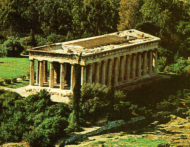
The Temple of Hephaestus in central Athens, Greece, is the best-preserved ancient Greek temple in the world, but is far less well-known than its illustrious neighbour, the Parthenon. The temple is also known as the Hephaesteum or Hephaesteion. It is sometimes called the Theseum, due to a belief current in Byzantine times that the bones of the legendary Greek hero Theseus were buried there; in fact the bones alleged to be those of Theseus were buried in the 5th century BC at another site nearer to the Acropolis.

The temple is located about 500m north-west of the Acropolis and about 1km due west of the modern centre of Athens, Syntagma Square. It was built in about 449 BC on what was then the western edge of the city of Athens, in a district which contained many foundries and metalwork shops. It was therefore dedicated to Hephaestos, the god of blacksmiths and metallurgy. It was designed by Ictinus, one of the architects who worked on the Parthenon. It stands on a slight rise and in ancient times commanded a fine view of the Agora.

Built of marble from Mount Pentelus, in the Doric style, the temple is hexastyle, that is with six columns under the pedimented ends, and has thirteen columns on each side (counting the corner columns twice). The temple is peripteral, with columns entirely surrounding the central enclosed cella. In the entablature there is the plain frieze that is expected with the sober Doric mode, but above it in the spaces between the triglyphs – which are like decoratively grooved beam-ends pegged into place – the labours of Heracles are depicted in bas-relief. Sculpted into the low-relief metope is the great story of Theseus and of his quest to kill the minotaur.

Unlike the Parthenon, the temple has all its columns and pediments intact, and even has most of its original roof. Its friezes and other decorations, however, have inevitably been badly damaged by thieves and looters over the centuries. It owes its survival to its conversion to a Christian Church, the Church of St George, in the 7th century AD. The survival of the exterior came at the cost of the ancient interior, which was removed and replaced by the structures of a Christian church.

During the centuries of Ottoman rule in Greece, the temple was the main Greek Orthodox church in Athens. When the first king of independent Greece, King Othon, entered the city in 1834, the service welcoming him to his new capital was held in the church.Today the temple has been preserved as an archaeological site under the supervision of the Ephorate of Antiquities of the Greek Interior Ministry. The temple itself has a small fence, but the visitor can get much closer than is possible at the Parthenon or most other antiquities in Greece. The temple is now surrounded by an ornamental garden. The site gets much less tourist traffic than the Acropolis and is a pleasant green spot in the heart of Athens.


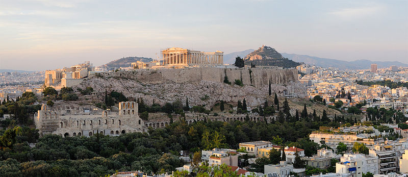
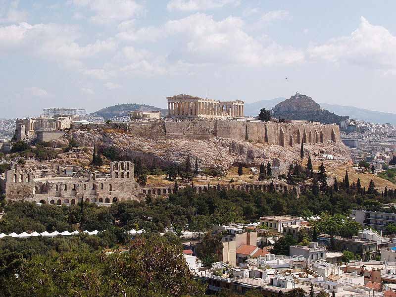
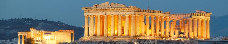
The Acropolis in Athens

The Acropolis is high above the city on a natural prominence.


Mount Olympus

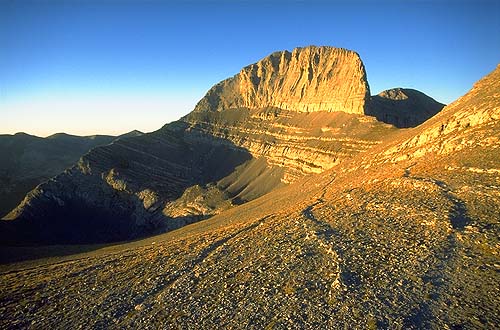
Mount Olympus s the highest mountain in Greece, at 2,917 (or 2,919, according to new measurements ) meters high; it is situated at 40°05 2N 22°21 2E, in mainland Greece.

Mount Olympus is noted for its very rich flora with several endemic species. The highest peak on Mount Olympus is Mitikas, which in Greek means “nose.” There are two refuges on a plain about forty five minutes away from Mitikas. Mitikas is the highest peak in Greece, the second highest being Stefani.

In Greek mythology, Mount Olympus is the home of the Twelve Olympians, the principal gods in the Greek pantheon. The Greeks thought of it as built up with crystal mansions wherein the gods, such as Zeus, dwelt. The etymology and meaning of the name Olympus (Olympos) is unknown, and it may be of Pre-Indo-European origin.


The Tumulus of Marathon

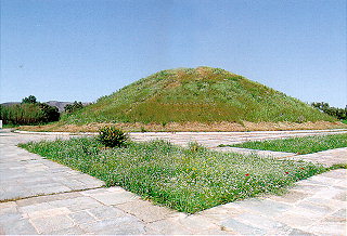
The fertile plain of Marathon was a natural place for the establishment and development of human activity from prehistoric to Roman times. Here on this plain the battle between the Athenians and the Persians was fought in 490 B.C. To this great event Marathon owes its worldwide fame and its important place in the conscience of the ancient Greeks. The Mound was raised over the graves of the 192 Athenians who died in the battle and whose remains were buried here after cremation of the dead.


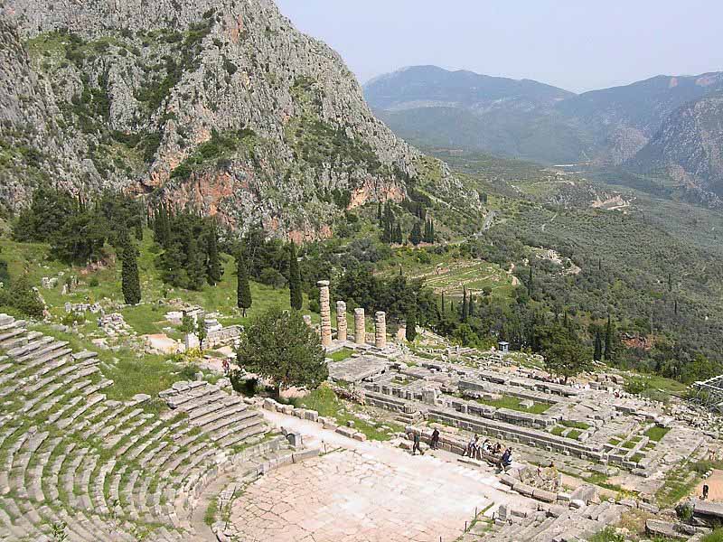
Theatre and Temple of Apollo in mountainous country at Delphi


Delphi, GreeceLocated about one hundred miles northwest of Athens is the ancient site of the panhellenic sanctuary of Delphi. The complex of buildings, which includes the Temple of Apollo where sat the famous oracle, The sacred Corycian Cave, and the Castalian Spring, is nestled in the forested slopes and rocky crags on the south side of the sacred mountain Mountains and the Sacred called Parnassus. The site had been sacred since at least the Bronze Age. According to legend, the shrine was originally guarded by the she-dragon Pytho. She was killed by Apollo who then took over the oracle. In antiquity, Delphi was regarded as the centre of the world.


Temple of Apollo
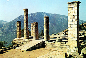
The visible ruins belong to the last temple, dated to the 4th century BCE, which was peripteral, in Doric order. It was erected on the remains of an earlier temple, dated to the 6th century BCE. Inside was the “adyton”, the centre of the Delphic oracle and seat of Pythia. The monument was partly restored during 1938-1941.


Castalian Spring

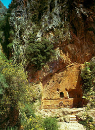
In Greece, the Phaedriades (“the shining ones”) were the pair of cliffs, ca 700 m high on the lower southern slope of Mt. Parnassos, which enclose the sacred site of Delphi, the center of the Hellenic world. Strabo, Plutarch and Pausanias all mentioned the Phaedriades in describing the site, a narrow valley of the Pleistus (today Xeropotamos) formed by Parnasse and Mt. Cirphis. Between them rises the Castalian Spring. Even today, at noontime, the rock faces reflect a dazzling glare.

The Castalian Spring in the ravine between the Phaedriades at Delphi is where all comers to Delphi, the contestants in the Pythian Games and especially suppliants who came to consult the Oracle, stopped to wash their hair. Two fountains fed by the sacred spring survive. The archaic (early 6th century BCE) fountain house has a marble-lined basin surrounded by benches. There is also a Hellenistic or Roman fountain with niches hollowed in the rock to receive votive gifts. The Castalian Spring predates all of classical Delphi: the archaic guardian of the spring was the serpent or dragon Python, killed by Apollo in its lair beside the spring.


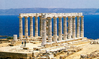
Sanctuary of Poseidon and Athena at Sounion

The sanctuary at Sounion is one of the most important sanctuaries in Attica. Sporadic finds point to the conclusion that the site was inhabited in the prehistoric period but there is no evidence of religious practice in such an early date. “Sounion Hiron” (sanctuary of Sounion) is first mentioned in the Odyssey, as the place where Menelaos stopped during his return from Troy to bury his helmsman, Phrontes Onetorides.

The finds of the 7th century B.C. are numerous and prove the existence of organized cult on two points of the promontory: at the southern edge where the temenos of Poseidon was situated, and about 500 m. to the NE of it, where the sanctuary of Athena was established.

Important votive offerings were dedicated during the 6th century B.C., but the architectural form of both sanctuaries remained unpretentious until the beginning of the 5th century B.C., when the Athenians initiated the construction of an imposing poros temple in the temenos of Poseidon.

The building was never completed, though, as both the temple and the offerings were destroyed by the Persians in 480 B.C. In the following decades, Sounion, like the rest of Attica, flourished, and an important building project was undertaken at both sanctuaries. At the end of the 5th century and during the Peloponnesian War, the Athenians fortified Sounion cape.

From the 1st century B.C. onwards, the sanctuaries gradually declined and Pausanias, who sailed along the coast of the promontory in the mid-2nd century A.D., wrongly considered the prominent temple on the top of the hill as the temple of Athena. The site of the temple was known in the following centuries, as is proved by descriptions of modern travelers, who visited Sounion before the excavations started, as well as by graffiti on the stones, among which, that made by Lord Byron.

Restricted excavations in the sanctuary of Poseidon were conducted in 1825 by the Dilettanti and by the German architect W. Doerpfeld. Systematic investigation was undertaken between 1897 and 1915 by the Athens Archaeological Society, under the direction of Val. Stais, with the collaboration of A. Orlandos. Since 1994, the Archaeological Society has been carrying out excavations at the Fortress.


Sanctuary of Poseidon

It is situated in the southernmost, highest part of the promontory. The area was evened off and supported by means of retaining walls on the north and west sides. A Propylon was constructed on the north side, and porticoes along the north and the east for the accommodation of the pilgrims. The site was dominated by the Classical temple.

At the end of the Archaic period an imposing temple was constructed in the position of the Classical one seen today, but it was slightly smaller in dimensions. It was Doric, made of poros, with an external colonnade of 6 x 13 columns, and an internal one which supported the roof. Its construction was interrupted by the Persian invasion and the temple remained unfinished.

The later temple, the one preserved today, was also Doric, with 6 x 13 columns, made of Agrileza marble, but without an internal colonnade. The stylobate measured 13,47 x 31,12 m. It was constructed in 450-440 B.C. and, according to another theory, was the work of the architect who had also built the Hephaisteion (“Theseion”) in the Ancient Agora of Athens, the Temple of Nemesis at Rhamnous, and the Temple of Ares which was probably erected in Acharnes.

The sculptural decoration of the temple, made of Parian marble, is preserved in a poor condition. The frieze of the east side depicted Centauromachy, and the east pediment (of which only a seated female figure is preserved) probably depicted the fight between Poseidon and Athena for the domination of Attica. The two antae of the east side and several of the columns of the east part of the temple are still preserved today, while the west is completely destroyed.

Propylon – Porticoes

The Propylon was constructed a little later than the Classical temple, and was made of marble and poros. It is Doric, distyle in antis on both sides (north and south). A partition wall inside the building has three doorways, of which the middle one is wider and has a ramp. A small rectangular hall is attached on the west wall of the Propylon, while porticoes are erected along the north and west sides of the sanctuary. The north of these porticoes is larger and slightly earlier.

The Fortress

Sounion cape was fortified in 412 B.C. during the Peloponnesian War, in order to control and secure the ships carrying cereals to Athens. The use of various materials and construction techniques is probably the result of repairs and additions made during the Chremonides’ War and the following years (266-229 B.C.). The sanctuary of Poseidon occupies the SE end of the fortress. The wall starts at the NE corner, extends to the north and turns to the west. Shipyards for the sheltering of two war ships were constructed on the coast, at the west end of the north branch of the fortification. Inside the fortress, excavations have brought to light part of a central street, remains of houses, and water cisterns.

Sanctuary of Athena

It is situated on a hill 500 m. to the NE of the Sanctuary of Poseidon. The area was evened off and enclosed with a poros polygonal circuit wall. Inside the enclosed area were erected the Temple of Athena, a smaller temple to the north, and altars. A deep pit on the SE side of the temenos was used as a deposit for the Archaic offerings destroyed by the Persians. The oval peribolos to the NW of the temenos has been identified as the “Heroon of Phrontes”.

Temple of Athena

It has a rectangular cella, measuring 16,4 x 11,6 m. The foundation of the pedestal supporting the cult statue is preserved on the west side of the cella, while four Ionic columns in the centre supported the roof. One of the peculiarities of the temple, mentioned also by Vitruvius, is the existence of an outer colonnade only on the east and south sides.

Some scholars consider that the temple of Athena Sounias was reconstructed after the mid-5th century B.C., while others believe that the cella was built during the Archaic period, was repaired after the Persian destructions, and the colonnade was added in the middle of the 5th century B.C. A second peculiarity of the sanctuary is the placement of the altar to the south of the temple.

Small Temple

Small, Doric, prostyle temple measuring 5 x 6.80 m., situated to the north of the Athena Temple. The pedestal of the cult statue is preserved inside the cella. The date of the structure and the identity of the deity worshipped is still a matter of debate.


The Ancient Agora of Athens
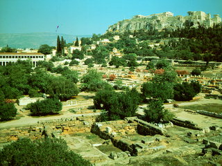
The Agora was the heart of ancient Athens, the focus of political, commercial, administrative and social activity, the religious and cultural center, and the seat of justice. The site was occupied without interruption in all periods of the city’s history. It was used as a residential and burial area as early as the Late Neolithic period (3000 B.C.). Early in the 6th century, in the time of Solon, the Agora became a public area.

After a series of repairs and remodeling, it reached its final rectangular form in the 2nd century B.C. Extensive building activity occurred after the serious damage made by the Persians in 480/79 B.C., by the Romans in 89 B.C. and by the Herulae in A.D. 267 while, after the Slavic invasion in A.D. 580, It was gradually abandoned. From the Byzantine period until after 1834, when Athens became the capital of the independent Greek state, the Agora was again developed as a residential area.

The first excavation campaigns were carried out by the Greek Archaeological Society in 1859-1912, and by the German Archaeological Institute in 1896-97. In 1890-91, a deep trench cut for the Athens-Peiraeus Railway brought to light extensive remains of ancient buildings. In 1931 the American School of Classical Studies started the systematic excavations with the financial support of J. Rockefeller and continued until 1941. Work was resumed in 1945 and is still continuing. In order to uncover the whole area of the Agora it was necessary to demolish around 400 modern buildings covering a total area of ca. 12 hectares.

In the 19th century the four colossal figures of Giants and Tritons at the facade of the Gymnasium were restored by the Greek Archaeological Society. In the years 1953-56, the Stoa of Attalos was reconstructed to become a museum and in the same period the Byzantine church of Aghioi Apostoloi, built around A.D. 1000, was restored by the American School. Between 1972 and 1975, restoration and preservation work was carried out at the Hephaisteion; the area was cleared of the vegetation, and the roof of the temple was repaired in 1978 by the Archaeological Service.


Stoa of Zeus Eleutherios

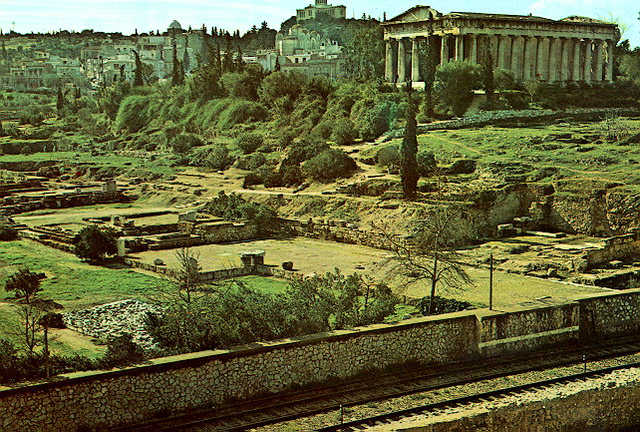
The stoa was erected at the end of the 5th century B.C. in honor of those who fought for the freedom and security of the city. Socrates is said to have met his friends in this stoa.

Temple of Apollo Patroos – Small Ionic temple, erected in ca. 340-320 B.C., identified as the temple of Apollo who was worshipped as the “Father” (Pater), the founder of the Ionian race. Inside the cella stood the cult statue of the god, made by the famous sculptor Euphranor.


Monument of the Eponymous Heroes

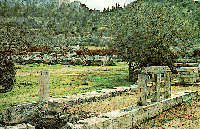
Remains of an oblong pedestal enclosed by a fence. It supported the bronze statues of the legendary heroes who gave their names to the ten tribes of Attica. In addition to its honorary function, the monument served as the official notice board of the city. It is dated to the second half of the 4th century B.C.
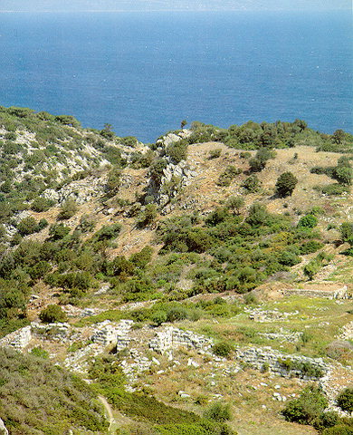


Rhamnous

The site of ‘Rhamnous,’ the northernmost deme of Attica, lies north of Marathon overlooking the Euboean Strait. The site was known in Antiquity for its sanctuary of Nemesis, the implacable avenging goddess. A fortified acropolis dominates the two small harbors, from which grain was imported for Athens during the Peloponnesian War. Otherwise, Rhamnous was strategically significant enough to be fortified and receive an Athenian garrison. Remains of the two temples can be seen. The 6th century Temple of Nemesis was destroyed by the Persians in 480 BCE and replaced by a never-completed temple in the 5th century. A smaller temple that shares the sanctuary platform (peribolos) is thought to have been dedicated to Thetis, based on the dedications of two marble seats, to Nemesis and to Thetis.


Fortress
The Fortress comprises an outer system 800 metres long and a smaller interior circuit enclosing the top of the hill. The main entrance of the outer system is at the south and it is protected by square towers at each side of the gate. Within the circuit private and public buildings have been found, notable among which are the theatre and the gymnasium. Within this same area is also the agora of the deme. Military establishments stood at the top of the hill – within the interior circuit of the fortification. On the coast below two small harbors – the eastern and the western – served the ships that patrolled the Euboian channel. The Fortress of Rhamnous, as that of Sounion at the southern tip of Attica, is thought to have been constructed during the Peloponnesian War in order to control the ships bringing grain to Athens.


Thorikos

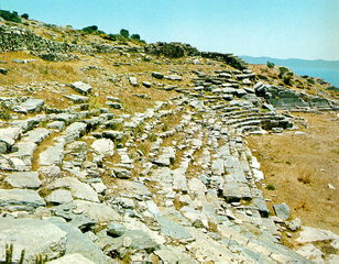
The hill known today as Velatouri is the centre of a Mycenaean settlement and also of the ancient deme of Thorikos. Preserved are the unusual theatre of the 6th-4th centuries B.C., parts of the settlement, some of the metal-working establishments, a square tower of the 4th century B.C., the cemeteries and the sanctuary of Demeter and Kore.

Between the years 1820 and 1995, excavations have been carried out by the Archaeological Society in Athens, the American School of Classical Studies, the Belgian Archaeological School, the 2nd Ephorate of Prehistoric and Classical Antiquities and by the Society of the Dilettanti.

The most important monuments and architectural units of the archaeological site are –

– The Mycenaean acropolis on the top of the Velatouri hill and the two tholos tombs of the same period.

– The Ancient Theatre of Thorikos. It is especially important for the history of the ancient theatre because of its unusual ellipsidal plan. Its original construction goes back to the 6th century B.C.

– ‘Industrial village’ – The central settlement of the ancient deme of Thorikos, which was a flourishing centre for the processing of metal from the Lavrion mines during the 5th and 4th centuries B.C. Roads and houses are spread out along the west slope of the Velatouri hill.

1 Comment

Filed under Humor and Observations

2,000-year-old treasure found in Black Sea fortress

2,000-year-old treasure found in Black Sea fortress

By Owen Jarus

Published January 10, 2013

LiveScience

  • Black Sea treasure 1.jpg

    Researchers working at the site of Artezian in the Crimea (Ukraine) have discovered two hoards of buried treasure (one hoard shown here) dating to A.D. 45, a time when the people of the citadel were under siege by the Roman army. Here, two silver anklets, beads, numerous coins and a white, glass flask with a two-headed face, one side serious and the other happy. (Russian-Ukrainian Archaeological Artezian Expedition)

  • Black Sea treasure.jpg

    The citadel was torched by the Roman army in A.D. 45, with many of its inhabitants likely killed. Some time afterward Artezian was rebuilt with stronger fortifications although it, along with the rest of the Bosporan Kingdom, was under the sway of Rome. (Russian-Ukrainian Archaeological Artezian Expedition)

Residents of a town under siege by the Roman army about 2,000 years ago buried two hoards of treasure in the town’s citadel — treasure recently excavated by archaeologists.

More than 200 coins, mainly bronze, were found along with “various items of gold, silver and bronze jewelry and glass vessels” inside an ancient fortress within the Artezian settlement in the Crimea (in Ukraine), the researchers wrote in the most recent edition of the journal Ancient Civilizations from Scythia to Siberia.

“The fortress had been besieged. Wealthy people from the settlement and the neighborhood had tried to hide there from the Romans. They had buried their hoards inside the citadel,” Nikolaï Vinokurov, a professor at Moscow State Pedagogical University, explained. [See Photos of the Buried Treasure]

‘They had buried their hoards inside the citadel.’

– Nikolaï Vinokurov, a professor at Moscow State Pedagogical University 

Artezian, which covered an area of at least 3.2 acres and also had a necropolis (a cemetery), was part of the Bosporus Kingdom. At the time, the kingdom’s fate was torn between two brothers —Mithridates VIII, who sought independence from Rome, and his younger brother, Cotys I, who was in favor of keeping the kingdom a client state of the growing empire. Rome sent an army to support Cotys, establishing him in the Bosporan capital and torching settlements controlled by Mithridates, including Artezian.

People huddled in the fortress for protection as the Romans attacked, but Vinokurov said they knew they were doomed. “We can say that these hoards were funeral sacrifices. It was obvious for the people that they were going to die shortly,” he wrote in an email to LiveScience. The siege and fall of the fortress occurred in AD 45.

Curiously, each hoard included exactly 55 coins minted by Mithridates VIII. “This is possibly just a simple coincidence, or perhaps these were equal sums received by the owners of these caskets from the supporters of Mithridates,” the team wrote in its paper.

A Greek lifestyle

Vinokurov’s team, including a number of volunteers, has been exploring Artezian since 1989 and has found that the people of the settlement followed a culture that was distinctly Greek. The population’s ethnicity was mixed, Vinokurov wrote, “but their culture was pure Greek. They spoke Greek language, had Greek school; the architecture and fortification were Greek as well. They were Hellenes by culture but not that pure by blood.”

Greeks are known to have created colonies on the Black Sea centuries earlier, intermarrying with the Crimeans. The customs and art forms they introduced appear to have persisted through the ages despite being practiced nearly 600 miles (1,000 kilometers) from Greece itself.

This Greek influence can be seen in the treasures the people of Artezian buried. Among them is a silver brooch engraved with an image of Aphrodite, the Greek goddess of love, and gold rings with gems engraved with images of Nemesis and Tyche, both Greek deities.

When archaeologists excavated other portions of the torched site they found more evidence of a Greek lifestyle.

“In the burnt level of the early citadel, many fragmentary small terra cotta figures were found depicting Demeter, Cora, Cybele, Aphrodite with a dolphin, Psyche and Eros, a maiden with gifts, Hermes, Attis, foot soldiers and warriors on horseback, semi-naked youths,” the researchers wrote in their paper, adding fragments of a miniature oinochoai (a form of Greek pottery) and small jugs for libations also were found.

All this was torched by the Romans and later rebuilt by Cotys I, who had been successfully enthroned by Rome. However the treasures of the earlier inhabitants remained undiscovered beneath the surface, a testament to a desperate stand against the growing power of Rome.

Read more: http://www.foxnews.com/science/2013/01/10/2000-year-old-treasure-discovered-in-black-sea-fortress/?intcmp=features#ixzz2Iq68lRoH

Leave a comment

Filed under Humor and Observations